12 gateways to Mechelen
Long ago our city was surrounded by an impressive defensive wall or rampart punctuated with 12 gates and several towers. The first wall was built of earth in the early 11th century. As the city grew, so did the need for a larger wall, which followed in the second half of the 13th century. By the end of the 14th century, it was built entirely of stone. Later on, cannons and other defence devices were placed on top of the wall.
Each gate had heavy doors, an iron fence, which could be lowered, a wooden drawbridge and all manner of outer fortifications. Many gateways had an outer gateway to defend the main gate and bridge. The gateways were interlinked by a wall with small towers and doors.
The gates, wall and moat, collectively known as the ‘vest/’vesten’ in Dutch, protected the city during a siege and served as points of controlled access to and departure from the walled city. Gunpowder and weapons were kept in many of the gatehouses. Some housed prisons where the mentally ill or soldiers might be incarcerated. In others, by contrast, specific products like herrings were on sale.
Travellers and traders often had to pay a toll to the gatekeeper, a major source of income for the city. In the first half of the 19th century, the large city gates were gradually dismantled along with the vest. Once demolished, they were replaced by small toll houses, charged with collecting octroi, a local tax levied on certain articles on their entry to the city.
Power and prosperity
As well as providing security and safety, prestige also played a role. The wall around the city formed the hard border between city and countryside. Towering, beautifully executed gatehouses, some resembling small castles, underlined the city’s might and prosperity and inspired wonder and awe in approaching travellers and other powers. A large chunk of the city’s revenue was therefore spent on maintaining and improving the vest.
City moat
As the city wall was surrounded by a moat, bridges provided the only access to the city. Those points of access were guarded by a gate, which could be raised to close off the city. Mechelen’s city canals were an important trade route for boats too.
Mechelen had a watermill complex, which also regulated the water level of the city moat. In the event of danger from outside, the water in the River Dyle outside the city was pumped into the city canal. This created a sort of swamp and made it impossible to enter the city by boat. When the outer Dyle to the north of the city – the Afleidingsdijle - was constructed(1893-1907), all these mills were dismantled. Only the Volmolen was spared. Today it houses the ViaVia café in the Botanical Garden.
In the 19th and 20th centuries, the southern half of the canal ring was filled in. The northern canal ring was widened and became the Afleidingsdijle.

Afleidingsdijle, 1900. © www.regionalebeeldbank.be
Fine boulevards, parks and verdant squares
Major changes in warfare at the beginning of the 19th century rendered city walls obsolete. Alterations were made to the wall around Mechelen and to many of its military buildings. For example, starting in the 19th century, large sections of the wall and a number of gates were dismantled. But the dismantling of the gates, walls and filling in of the canals served another purpose too: that of making the city a pleasanter and more attractive place. Fine boulevards and green spaces were created on the site of the demolished city walls and gates, and large numbers of trees such as elms, oaks, linden and Canadian poplars were planted.

Hendrik Speecqvest,1900. © www.regionalebeeldbank.be
Over the years, however, the vesten were altered to accommodate the increasing levels of motorized vehicles and the tram lines running round and through the city. Green spaces were replaced by asphalt. Cyclists and pedestrians were squeezed out.
The Nieuwe Vesten scheme aims to restore the balance. There will be more space for cyclists, pedestrians and public transport, while still leaving enough room for motorized vehicles. This will make for increased safety and more green spaces too.
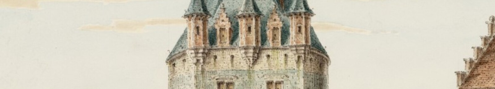
About the illustrations of the gates
The 3D images of the gates you see on our website are by Wilfried Montald from Mechelen. He set out to bring the fascinating history of the city gates back to life. Wilfried, who started this hobby in the middle of the pandemic, eventually wants to recreate the whole city as it was around the 16th and 17th centuries. The images you see here are only of the city walls and gates. He still has work to do on the surrounding area. His impressions approach history as accurately as possible. You can view more of his work at montald.com.
The other images you see here are from the Mechelen City Archive. If you would like to delve into history yourself, you will find lots of information at stadsarchiefmechelen.be and regionalebeeldank.be.
